Wellington Crescent Riverbank, Path, and Roadway Project
Public engagement is closed.
Introduction
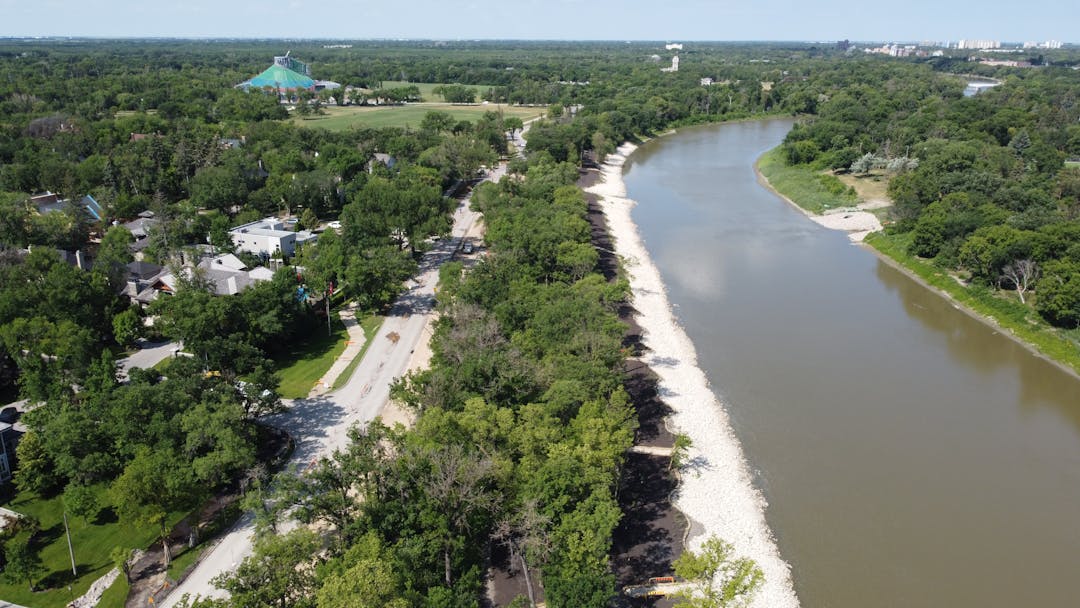
The City of Winnipeg (the City) investigated how best to protect City infrastructure and preserve the south bank of the Assiniboine River on Wellington Crescent between Assiniboine Park and Doncaster Street. Stabilizing the bank is necessary to protect underground utilities and the nearby path and road from further riverbank failure.
Various options to manage riverbank related risks were evaluated to determine the best approach for protecting City assets and amenities.
Background
In the summer of 2016, cracks appeared in the walk bike path along Wellington Crescent near Lamont Boulevard. The City was monitoring the area and found that the cracking was caused by riverbank movement. The riverbank movement continued to worsen, and in July 2017 the riverbank failed. The walk bike path was closed for safety reasons and a temporary gravel detour was built along the north curb of Wellington Crescent. The riverbank monitoring also identified potential risks to the path and street at other locations within the project area.
In September 2018, the City began investigating solutions for the project area. The Wellington Crescent Riverbank, Path, and Roadway Project seeks to:
- Protect the streets, paths, lighting and underground utilities from the impacts of ongoing erosion and movement by stabilizing the riverbank or relocating infrastructure out of high risk zones
- Preserve the riverbank with erosion protection and stability improvements along the south bank of the Assiniboine River
- Restore the damaged walk bike path or construct a new paved path in a different location along Wellington Crescent
Introduction
The City of Winnipeg (the City) investigated how best to protect City infrastructure and preserve the south bank of the Assiniboine River on Wellington Crescent between Assiniboine Park and Doncaster Street. Stabilizing the bank is necessary to protect underground utilities and the nearby path and road from further riverbank failure.
Various options to manage riverbank related risks were evaluated to determine the best approach for protecting City assets and amenities.
Background
In the summer of 2016, cracks appeared in the walk bike path along Wellington Crescent near Lamont Boulevard. The City was monitoring the area and found that the cracking was caused by riverbank movement. The riverbank movement continued to worsen, and in July 2017 the riverbank failed. The walk bike path was closed for safety reasons and a temporary gravel detour was built along the north curb of Wellington Crescent. The riverbank monitoring also identified potential risks to the path and street at other locations within the project area.
In September 2018, the City began investigating solutions for the project area. The Wellington Crescent Riverbank, Path, and Roadway Project seeks to:
- Protect the streets, paths, lighting and underground utilities from the impacts of ongoing erosion and movement by stabilizing the riverbank or relocating infrastructure out of high risk zones
- Preserve the riverbank with erosion protection and stability improvements along the south bank of the Assiniboine River
- Restore the damaged walk bike path or construct a new paved path in a different location along Wellington Crescent
Public engagement is closed.
Have a question about this project? Connect with the project team using the Q&A. We will aim to provide an answer in five business days.
-
Share A PDF document was forwarded on July 19, 2020 by email to the Engage Winnipeg office for review by the project design team. We are requesting that the City’s written comments to that PDF be posted on this Q&A website for viewing and education by the public. As an overview of the submitted PDF, it contained analysis and recommendations from the public for an alternative to the City’s Strategies 1, 2 and 3. ------- Since there is no link for the public to be able to post that PDF onto this Q&A website, below is a summary of some of the key points from that PDF document. Project team -- for transparency for the public, please post your response to the emailed PDF onto this Q&A website rather than emailing your response only to the sender’s email address. --- 1 --- The City’s selected Strategy 2 consists of installing riprap along the entire riverbank from roughly Doncaster Street to just west of Park Boulevard and shear keys that extend along most of that length. ---2 --- However, experience by the authors of the PDF has led them to believe that much of the damage that the City’s presentation attributes to riverbank erosion is in fact coming from another threat, i.e. large volumes of unmanaged surface water run-off from rain, snow melt, private sprinkler systems, etc. i.e. See Notes 3 and 4 below for more detail. --- 3 --- “The Assiniboine Park Pavement Failure” occurred in an area immediately north of the collector ditch which is located on the south side of Assiniboine Park Drive. Note that the outlet serves a very large catchment of water from the Frisbee field. The water is dumped immediately north of the pavement. The impounded water to the south and the outflow to the north likely caused or greatly contributed to the failure. --- 4 --- “The Walk Bike Path Failure” occurred in an area immediately north of the storm drain outlet located on the north side of Wellington Cr. There is often a lot of water flow here and this probably caused or greatly contributed to the failure. Is it possible that if this water were properly channeled into the river then the soil would not be so saturated and less likely to fail going forward? --- 5 --- At a time when the City is struggling with finances, rather than proceeding with the entire Strategy solution as a single phase, why not break the implementation of the Strategy into two subphases, as follows: (a) implement the 1st phase with beefed up run-off water management with proper storm drainage controls as shown on the PDF maps submitted, observe the outcome; and (b) then proceed into 2nd phase with rip rap and shear key ONLY if the observed remediation from the 1st phase proves insufficient on its own. --- 6 --- The savings from this two-subphased approach might well run into several million dollars for the taxpayers of this City. on Facebook Share A PDF document was forwarded on July 19, 2020 by email to the Engage Winnipeg office for review by the project design team. We are requesting that the City’s written comments to that PDF be posted on this Q&A website for viewing and education by the public. As an overview of the submitted PDF, it contained analysis and recommendations from the public for an alternative to the City’s Strategies 1, 2 and 3. ------- Since there is no link for the public to be able to post that PDF onto this Q&A website, below is a summary of some of the key points from that PDF document. Project team -- for transparency for the public, please post your response to the emailed PDF onto this Q&A website rather than emailing your response only to the sender’s email address. --- 1 --- The City’s selected Strategy 2 consists of installing riprap along the entire riverbank from roughly Doncaster Street to just west of Park Boulevard and shear keys that extend along most of that length. ---2 --- However, experience by the authors of the PDF has led them to believe that much of the damage that the City’s presentation attributes to riverbank erosion is in fact coming from another threat, i.e. large volumes of unmanaged surface water run-off from rain, snow melt, private sprinkler systems, etc. i.e. See Notes 3 and 4 below for more detail. --- 3 --- “The Assiniboine Park Pavement Failure” occurred in an area immediately north of the collector ditch which is located on the south side of Assiniboine Park Drive. Note that the outlet serves a very large catchment of water from the Frisbee field. The water is dumped immediately north of the pavement. The impounded water to the south and the outflow to the north likely caused or greatly contributed to the failure. --- 4 --- “The Walk Bike Path Failure” occurred in an area immediately north of the storm drain outlet located on the north side of Wellington Cr. There is often a lot of water flow here and this probably caused or greatly contributed to the failure. Is it possible that if this water were properly channeled into the river then the soil would not be so saturated and less likely to fail going forward? --- 5 --- At a time when the City is struggling with finances, rather than proceeding with the entire Strategy solution as a single phase, why not break the implementation of the Strategy into two subphases, as follows: (a) implement the 1st phase with beefed up run-off water management with proper storm drainage controls as shown on the PDF maps submitted, observe the outcome; and (b) then proceed into 2nd phase with rip rap and shear key ONLY if the observed remediation from the 1st phase proves insufficient on its own. --- 6 --- The savings from this two-subphased approach might well run into several million dollars for the taxpayers of this City. on Twitter Share A PDF document was forwarded on July 19, 2020 by email to the Engage Winnipeg office for review by the project design team. We are requesting that the City’s written comments to that PDF be posted on this Q&A website for viewing and education by the public. As an overview of the submitted PDF, it contained analysis and recommendations from the public for an alternative to the City’s Strategies 1, 2 and 3. ------- Since there is no link for the public to be able to post that PDF onto this Q&A website, below is a summary of some of the key points from that PDF document. Project team -- for transparency for the public, please post your response to the emailed PDF onto this Q&A website rather than emailing your response only to the sender’s email address. --- 1 --- The City’s selected Strategy 2 consists of installing riprap along the entire riverbank from roughly Doncaster Street to just west of Park Boulevard and shear keys that extend along most of that length. ---2 --- However, experience by the authors of the PDF has led them to believe that much of the damage that the City’s presentation attributes to riverbank erosion is in fact coming from another threat, i.e. large volumes of unmanaged surface water run-off from rain, snow melt, private sprinkler systems, etc. i.e. See Notes 3 and 4 below for more detail. --- 3 --- “The Assiniboine Park Pavement Failure” occurred in an area immediately north of the collector ditch which is located on the south side of Assiniboine Park Drive. Note that the outlet serves a very large catchment of water from the Frisbee field. The water is dumped immediately north of the pavement. The impounded water to the south and the outflow to the north likely caused or greatly contributed to the failure. --- 4 --- “The Walk Bike Path Failure” occurred in an area immediately north of the storm drain outlet located on the north side of Wellington Cr. There is often a lot of water flow here and this probably caused or greatly contributed to the failure. Is it possible that if this water were properly channeled into the river then the soil would not be so saturated and less likely to fail going forward? --- 5 --- At a time when the City is struggling with finances, rather than proceeding with the entire Strategy solution as a single phase, why not break the implementation of the Strategy into two subphases, as follows: (a) implement the 1st phase with beefed up run-off water management with proper storm drainage controls as shown on the PDF maps submitted, observe the outcome; and (b) then proceed into 2nd phase with rip rap and shear key ONLY if the observed remediation from the 1st phase proves insufficient on its own. --- 6 --- The savings from this two-subphased approach might well run into several million dollars for the taxpayers of this City. on Linkedin Email A PDF document was forwarded on July 19, 2020 by email to the Engage Winnipeg office for review by the project design team. We are requesting that the City’s written comments to that PDF be posted on this Q&A website for viewing and education by the public. As an overview of the submitted PDF, it contained analysis and recommendations from the public for an alternative to the City’s Strategies 1, 2 and 3. ------- Since there is no link for the public to be able to post that PDF onto this Q&A website, below is a summary of some of the key points from that PDF document. Project team -- for transparency for the public, please post your response to the emailed PDF onto this Q&A website rather than emailing your response only to the sender’s email address. --- 1 --- The City’s selected Strategy 2 consists of installing riprap along the entire riverbank from roughly Doncaster Street to just west of Park Boulevard and shear keys that extend along most of that length. ---2 --- However, experience by the authors of the PDF has led them to believe that much of the damage that the City’s presentation attributes to riverbank erosion is in fact coming from another threat, i.e. large volumes of unmanaged surface water run-off from rain, snow melt, private sprinkler systems, etc. i.e. See Notes 3 and 4 below for more detail. --- 3 --- “The Assiniboine Park Pavement Failure” occurred in an area immediately north of the collector ditch which is located on the south side of Assiniboine Park Drive. Note that the outlet serves a very large catchment of water from the Frisbee field. The water is dumped immediately north of the pavement. The impounded water to the south and the outflow to the north likely caused or greatly contributed to the failure. --- 4 --- “The Walk Bike Path Failure” occurred in an area immediately north of the storm drain outlet located on the north side of Wellington Cr. There is often a lot of water flow here and this probably caused or greatly contributed to the failure. Is it possible that if this water were properly channeled into the river then the soil would not be so saturated and less likely to fail going forward? --- 5 --- At a time when the City is struggling with finances, rather than proceeding with the entire Strategy solution as a single phase, why not break the implementation of the Strategy into two subphases, as follows: (a) implement the 1st phase with beefed up run-off water management with proper storm drainage controls as shown on the PDF maps submitted, observe the outcome; and (b) then proceed into 2nd phase with rip rap and shear key ONLY if the observed remediation from the 1st phase proves insufficient on its own. --- 6 --- The savings from this two-subphased approach might well run into several million dollars for the taxpayers of this City. link
A PDF document was forwarded on July 19, 2020 by email to the Engage Winnipeg office for review by the project design team. We are requesting that the City’s written comments to that PDF be posted on this Q&A website for viewing and education by the public. As an overview of the submitted PDF, it contained analysis and recommendations from the public for an alternative to the City’s Strategies 1, 2 and 3. ------- Since there is no link for the public to be able to post that PDF onto this Q&A website, below is a summary of some of the key points from that PDF document. Project team -- for transparency for the public, please post your response to the emailed PDF onto this Q&A website rather than emailing your response only to the sender’s email address. --- 1 --- The City’s selected Strategy 2 consists of installing riprap along the entire riverbank from roughly Doncaster Street to just west of Park Boulevard and shear keys that extend along most of that length. ---2 --- However, experience by the authors of the PDF has led them to believe that much of the damage that the City’s presentation attributes to riverbank erosion is in fact coming from another threat, i.e. large volumes of unmanaged surface water run-off from rain, snow melt, private sprinkler systems, etc. i.e. See Notes 3 and 4 below for more detail. --- 3 --- “The Assiniboine Park Pavement Failure” occurred in an area immediately north of the collector ditch which is located on the south side of Assiniboine Park Drive. Note that the outlet serves a very large catchment of water from the Frisbee field. The water is dumped immediately north of the pavement. The impounded water to the south and the outflow to the north likely caused or greatly contributed to the failure. --- 4 --- “The Walk Bike Path Failure” occurred in an area immediately north of the storm drain outlet located on the north side of Wellington Cr. There is often a lot of water flow here and this probably caused or greatly contributed to the failure. Is it possible that if this water were properly channeled into the river then the soil would not be so saturated and less likely to fail going forward? --- 5 --- At a time when the City is struggling with finances, rather than proceeding with the entire Strategy solution as a single phase, why not break the implementation of the Strategy into two subphases, as follows: (a) implement the 1st phase with beefed up run-off water management with proper storm drainage controls as shown on the PDF maps submitted, observe the outcome; and (b) then proceed into 2nd phase with rip rap and shear key ONLY if the observed remediation from the 1st phase proves insufficient on its own. --- 6 --- The savings from this two-subphased approach might well run into several million dollars for the taxpayers of this City.
Neighbour asked almost 6 years agoThe project team has received your PowerPoint submission. Unfortunately, this Q&A tool does not have the capability to post PDFs. Comments on the submission are below.
Surface runoff has been identified as a factor since the project outset and has been considered by the design team through all phases of the project, even though details regarding land-drainage management have not been shown prominently in the project information. Surface runoff can contribute to geotechnical instability and riverbank erosion; however, additional factors include groundwater conditions, river levels, flow velocities, riverbank slope geometry, ground cover, and soil type, properties, and stratigraphy. The recommended design for this project considers all these factors. On this project, surface runoff is not considered to be the principal causal factor, therefore a solution that only considers surface runoff would be insufficient to achieve the geotechnical stability targets required to protect City assets. Therefore a phased approach is not recommended. Deferral of the recommended stabilization work carries with it a risk that more widespread riverbank failures will occur, and it is more costly to repair failed riverbanks compared to riverbanks that have not yet failed. Therefore deferral of the stabilization work carries with it substantial financial risk.
-
Share As the project advances through its preliminary design stage, if the project design were to propose a single recreational path to replace the existing single path, the new path would become very congested over the next 20 years as new types of recreational activities that are yet to be invented and become common place. It would appear that the design of a single recreational path assumes future usage is the same as today’s users; however the planning of a new recreational path should be able to accommodate a much wider variety of unknown fast and slow-moving human and pet traffic than the design that a single path can manage, including: Walking, Jogging, Bicycling, Roller blading, Skate boarding, Nordic roller skiing, Dockless electric bikes, Scooter sharing, Seniors assistive walking devices, Seniors power mobility scooters, Manual and electric wheelchairs, Etc. i.e. Careful thought needs to be put into avoiding congestion and avoid harming pedestrians from others using various types of mobility equipment on the same path for future types of travellers. on Facebook Share As the project advances through its preliminary design stage, if the project design were to propose a single recreational path to replace the existing single path, the new path would become very congested over the next 20 years as new types of recreational activities that are yet to be invented and become common place. It would appear that the design of a single recreational path assumes future usage is the same as today’s users; however the planning of a new recreational path should be able to accommodate a much wider variety of unknown fast and slow-moving human and pet traffic than the design that a single path can manage, including: Walking, Jogging, Bicycling, Roller blading, Skate boarding, Nordic roller skiing, Dockless electric bikes, Scooter sharing, Seniors assistive walking devices, Seniors power mobility scooters, Manual and electric wheelchairs, Etc. i.e. Careful thought needs to be put into avoiding congestion and avoid harming pedestrians from others using various types of mobility equipment on the same path for future types of travellers. on Twitter Share As the project advances through its preliminary design stage, if the project design were to propose a single recreational path to replace the existing single path, the new path would become very congested over the next 20 years as new types of recreational activities that are yet to be invented and become common place. It would appear that the design of a single recreational path assumes future usage is the same as today’s users; however the planning of a new recreational path should be able to accommodate a much wider variety of unknown fast and slow-moving human and pet traffic than the design that a single path can manage, including: Walking, Jogging, Bicycling, Roller blading, Skate boarding, Nordic roller skiing, Dockless electric bikes, Scooter sharing, Seniors assistive walking devices, Seniors power mobility scooters, Manual and electric wheelchairs, Etc. i.e. Careful thought needs to be put into avoiding congestion and avoid harming pedestrians from others using various types of mobility equipment on the same path for future types of travellers. on Linkedin Email As the project advances through its preliminary design stage, if the project design were to propose a single recreational path to replace the existing single path, the new path would become very congested over the next 20 years as new types of recreational activities that are yet to be invented and become common place. It would appear that the design of a single recreational path assumes future usage is the same as today’s users; however the planning of a new recreational path should be able to accommodate a much wider variety of unknown fast and slow-moving human and pet traffic than the design that a single path can manage, including: Walking, Jogging, Bicycling, Roller blading, Skate boarding, Nordic roller skiing, Dockless electric bikes, Scooter sharing, Seniors assistive walking devices, Seniors power mobility scooters, Manual and electric wheelchairs, Etc. i.e. Careful thought needs to be put into avoiding congestion and avoid harming pedestrians from others using various types of mobility equipment on the same path for future types of travellers. link
As the project advances through its preliminary design stage, if the project design were to propose a single recreational path to replace the existing single path, the new path would become very congested over the next 20 years as new types of recreational activities that are yet to be invented and become common place. It would appear that the design of a single recreational path assumes future usage is the same as today’s users; however the planning of a new recreational path should be able to accommodate a much wider variety of unknown fast and slow-moving human and pet traffic than the design that a single path can manage, including: Walking, Jogging, Bicycling, Roller blading, Skate boarding, Nordic roller skiing, Dockless electric bikes, Scooter sharing, Seniors assistive walking devices, Seniors power mobility scooters, Manual and electric wheelchairs, Etc. i.e. Careful thought needs to be put into avoiding congestion and avoid harming pedestrians from others using various types of mobility equipment on the same path for future types of travellers.
transparency asked almost 6 years agoThroughout the project area, the proposed walk bike path near the road will be 3.5m wide to accommodate current and future usage, and multiple modes. The preliminary design has also identified opportunities for nature trails through the forest and riverbank areas.
-
Share Major redevelopments in Assiniboine Park by the Conservancy do not appear to have been integrated with the Wellington Riverbank design process ------ It would be beneficial for the Assiniboine Park Conservancy to be invited to play an ONGOING and ACTIVE partnership role on the project design team as soon as possible. From reviewing the City’s Library of Documents for this project, it appears silent to the design team on what the Conservancy has in mind over the next 20 years that could beneficially tie in and create opportunities to create interesting enhancements for the Wellington Crescent project. To illustrate the City’s very narrow perspective of isolating the project, below is one the questions recently posted by the public on the Q&A section of the City’s engagement website. In the City’s response, it stated “that the project is not related to Assiniboine Park.” Question by the public --- “Are there specific plans for the "new" roadway? Will it remain a 2 lane residential road or not? Is it intended to handle the park visitors as a primary gateway for the Diversity Gardens? There seems to be many unanswered questions and details.” Answer by the City --- “The project intends to stabilize the riverbank to protect underground utilities, the nearby path, and road from further riverbank failure, and is not related to Canada’s Diversity Gardens in Assiniboine Park.” However, Wellington Crescent is the only corridor that funnels tourist and recreational visitors into and from the EAST SIDE of Assiniboine Park. It is noticeably absent that the design focus appears to be on how to manage the flow of vehicles and human traffic eastbound away from Assiniboine Park but has not seized upon the opportunity to enhance the experience of vehicle modes and other movement modes as they travel westbound into Assiniboine Park. The metaphor is that Assiniboine Park is an anchor tenant in a strip mall with the strip being Wellington Crescent. Other than future traffic volumes perhaps increasing along Wellington Crescent, there appears to be isolation so far in the design for any significant staging of visitor expectations as they approach Assiniboine Park from the east by vehicle, on foot or by various modes of self-propelled travel. on Facebook Share Major redevelopments in Assiniboine Park by the Conservancy do not appear to have been integrated with the Wellington Riverbank design process ------ It would be beneficial for the Assiniboine Park Conservancy to be invited to play an ONGOING and ACTIVE partnership role on the project design team as soon as possible. From reviewing the City’s Library of Documents for this project, it appears silent to the design team on what the Conservancy has in mind over the next 20 years that could beneficially tie in and create opportunities to create interesting enhancements for the Wellington Crescent project. To illustrate the City’s very narrow perspective of isolating the project, below is one the questions recently posted by the public on the Q&A section of the City’s engagement website. In the City’s response, it stated “that the project is not related to Assiniboine Park.” Question by the public --- “Are there specific plans for the "new" roadway? Will it remain a 2 lane residential road or not? Is it intended to handle the park visitors as a primary gateway for the Diversity Gardens? There seems to be many unanswered questions and details.” Answer by the City --- “The project intends to stabilize the riverbank to protect underground utilities, the nearby path, and road from further riverbank failure, and is not related to Canada’s Diversity Gardens in Assiniboine Park.” However, Wellington Crescent is the only corridor that funnels tourist and recreational visitors into and from the EAST SIDE of Assiniboine Park. It is noticeably absent that the design focus appears to be on how to manage the flow of vehicles and human traffic eastbound away from Assiniboine Park but has not seized upon the opportunity to enhance the experience of vehicle modes and other movement modes as they travel westbound into Assiniboine Park. The metaphor is that Assiniboine Park is an anchor tenant in a strip mall with the strip being Wellington Crescent. Other than future traffic volumes perhaps increasing along Wellington Crescent, there appears to be isolation so far in the design for any significant staging of visitor expectations as they approach Assiniboine Park from the east by vehicle, on foot or by various modes of self-propelled travel. on Twitter Share Major redevelopments in Assiniboine Park by the Conservancy do not appear to have been integrated with the Wellington Riverbank design process ------ It would be beneficial for the Assiniboine Park Conservancy to be invited to play an ONGOING and ACTIVE partnership role on the project design team as soon as possible. From reviewing the City’s Library of Documents for this project, it appears silent to the design team on what the Conservancy has in mind over the next 20 years that could beneficially tie in and create opportunities to create interesting enhancements for the Wellington Crescent project. To illustrate the City’s very narrow perspective of isolating the project, below is one the questions recently posted by the public on the Q&A section of the City’s engagement website. In the City’s response, it stated “that the project is not related to Assiniboine Park.” Question by the public --- “Are there specific plans for the "new" roadway? Will it remain a 2 lane residential road or not? Is it intended to handle the park visitors as a primary gateway for the Diversity Gardens? There seems to be many unanswered questions and details.” Answer by the City --- “The project intends to stabilize the riverbank to protect underground utilities, the nearby path, and road from further riverbank failure, and is not related to Canada’s Diversity Gardens in Assiniboine Park.” However, Wellington Crescent is the only corridor that funnels tourist and recreational visitors into and from the EAST SIDE of Assiniboine Park. It is noticeably absent that the design focus appears to be on how to manage the flow of vehicles and human traffic eastbound away from Assiniboine Park but has not seized upon the opportunity to enhance the experience of vehicle modes and other movement modes as they travel westbound into Assiniboine Park. The metaphor is that Assiniboine Park is an anchor tenant in a strip mall with the strip being Wellington Crescent. Other than future traffic volumes perhaps increasing along Wellington Crescent, there appears to be isolation so far in the design for any significant staging of visitor expectations as they approach Assiniboine Park from the east by vehicle, on foot or by various modes of self-propelled travel. on Linkedin Email Major redevelopments in Assiniboine Park by the Conservancy do not appear to have been integrated with the Wellington Riverbank design process ------ It would be beneficial for the Assiniboine Park Conservancy to be invited to play an ONGOING and ACTIVE partnership role on the project design team as soon as possible. From reviewing the City’s Library of Documents for this project, it appears silent to the design team on what the Conservancy has in mind over the next 20 years that could beneficially tie in and create opportunities to create interesting enhancements for the Wellington Crescent project. To illustrate the City’s very narrow perspective of isolating the project, below is one the questions recently posted by the public on the Q&A section of the City’s engagement website. In the City’s response, it stated “that the project is not related to Assiniboine Park.” Question by the public --- “Are there specific plans for the "new" roadway? Will it remain a 2 lane residential road or not? Is it intended to handle the park visitors as a primary gateway for the Diversity Gardens? There seems to be many unanswered questions and details.” Answer by the City --- “The project intends to stabilize the riverbank to protect underground utilities, the nearby path, and road from further riverbank failure, and is not related to Canada’s Diversity Gardens in Assiniboine Park.” However, Wellington Crescent is the only corridor that funnels tourist and recreational visitors into and from the EAST SIDE of Assiniboine Park. It is noticeably absent that the design focus appears to be on how to manage the flow of vehicles and human traffic eastbound away from Assiniboine Park but has not seized upon the opportunity to enhance the experience of vehicle modes and other movement modes as they travel westbound into Assiniboine Park. The metaphor is that Assiniboine Park is an anchor tenant in a strip mall with the strip being Wellington Crescent. Other than future traffic volumes perhaps increasing along Wellington Crescent, there appears to be isolation so far in the design for any significant staging of visitor expectations as they approach Assiniboine Park from the east by vehicle, on foot or by various modes of self-propelled travel. link
Major redevelopments in Assiniboine Park by the Conservancy do not appear to have been integrated with the Wellington Riverbank design process ------ It would be beneficial for the Assiniboine Park Conservancy to be invited to play an ONGOING and ACTIVE partnership role on the project design team as soon as possible. From reviewing the City’s Library of Documents for this project, it appears silent to the design team on what the Conservancy has in mind over the next 20 years that could beneficially tie in and create opportunities to create interesting enhancements for the Wellington Crescent project. To illustrate the City’s very narrow perspective of isolating the project, below is one the questions recently posted by the public on the Q&A section of the City’s engagement website. In the City’s response, it stated “that the project is not related to Assiniboine Park.” Question by the public --- “Are there specific plans for the "new" roadway? Will it remain a 2 lane residential road or not? Is it intended to handle the park visitors as a primary gateway for the Diversity Gardens? There seems to be many unanswered questions and details.” Answer by the City --- “The project intends to stabilize the riverbank to protect underground utilities, the nearby path, and road from further riverbank failure, and is not related to Canada’s Diversity Gardens in Assiniboine Park.” However, Wellington Crescent is the only corridor that funnels tourist and recreational visitors into and from the EAST SIDE of Assiniboine Park. It is noticeably absent that the design focus appears to be on how to manage the flow of vehicles and human traffic eastbound away from Assiniboine Park but has not seized upon the opportunity to enhance the experience of vehicle modes and other movement modes as they travel westbound into Assiniboine Park. The metaphor is that Assiniboine Park is an anchor tenant in a strip mall with the strip being Wellington Crescent. Other than future traffic volumes perhaps increasing along Wellington Crescent, there appears to be isolation so far in the design for any significant staging of visitor expectations as they approach Assiniboine Park from the east by vehicle, on foot or by various modes of self-propelled travel.
transparency asked almost 6 years agoThe City has met with and been in discussion with the Assiniboine Park Conservancy (APC) regarding this project. Discussions with the APC will ensure that the project meets the needs of both the APC and the City. The City will continue to consult with the Assiniboine Park Conservancy as this project progresses.
-
Share Implement 3rd parties to avoid the risk of conflicts of interest and public mistrust ------ The City of Winnipeg has an unfortunate reputation for major cost overruns on high profile construction projects, with the new Police Headquarters building being an example. Therefore, for the Wellington Riverbank Project, it would be prudent for the City to engage two independent, arms length firms commencing immediately, notably: 1 ---- An independent costing firm to review/audit the costing accuracy and its thoroughness on a per diem basis. Such an outside firm would not have a vested interest in the magnitude of the project cost since their fees should be based upon the number of hours spent on the review not being paid as a percentage of the dollar magnitude of the project. 2 ---- For taxpayers, as soon as possible the City should also engage a Fairness Monitor, also known as an independent Fairness Auditor or Fairness Commissioner, to continuously audit the PROCESS of the project by examining the project’s procedures and report to City Council on the OUTCOMES at all stages in the project. Ideally the Fairness Monitor should be engaged from the start of the project and conclude their services only once the project is completed and all finances reconciled. The focus should not be only be on financial matters but also on the effectiveness of the community engagement process and the transparency, openness, fairness and impartiality of all aspects of this project. This type of work is not a financial audit performed by accountants who focus primarily on finances and fraud examination. The City has hired Fairness Commissioners in the past for real estate projects so it is timely to apply this independent role to all City construction projects not just real estate. on Facebook Share Implement 3rd parties to avoid the risk of conflicts of interest and public mistrust ------ The City of Winnipeg has an unfortunate reputation for major cost overruns on high profile construction projects, with the new Police Headquarters building being an example. Therefore, for the Wellington Riverbank Project, it would be prudent for the City to engage two independent, arms length firms commencing immediately, notably: 1 ---- An independent costing firm to review/audit the costing accuracy and its thoroughness on a per diem basis. Such an outside firm would not have a vested interest in the magnitude of the project cost since their fees should be based upon the number of hours spent on the review not being paid as a percentage of the dollar magnitude of the project. 2 ---- For taxpayers, as soon as possible the City should also engage a Fairness Monitor, also known as an independent Fairness Auditor or Fairness Commissioner, to continuously audit the PROCESS of the project by examining the project’s procedures and report to City Council on the OUTCOMES at all stages in the project. Ideally the Fairness Monitor should be engaged from the start of the project and conclude their services only once the project is completed and all finances reconciled. The focus should not be only be on financial matters but also on the effectiveness of the community engagement process and the transparency, openness, fairness and impartiality of all aspects of this project. This type of work is not a financial audit performed by accountants who focus primarily on finances and fraud examination. The City has hired Fairness Commissioners in the past for real estate projects so it is timely to apply this independent role to all City construction projects not just real estate. on Twitter Share Implement 3rd parties to avoid the risk of conflicts of interest and public mistrust ------ The City of Winnipeg has an unfortunate reputation for major cost overruns on high profile construction projects, with the new Police Headquarters building being an example. Therefore, for the Wellington Riverbank Project, it would be prudent for the City to engage two independent, arms length firms commencing immediately, notably: 1 ---- An independent costing firm to review/audit the costing accuracy and its thoroughness on a per diem basis. Such an outside firm would not have a vested interest in the magnitude of the project cost since their fees should be based upon the number of hours spent on the review not being paid as a percentage of the dollar magnitude of the project. 2 ---- For taxpayers, as soon as possible the City should also engage a Fairness Monitor, also known as an independent Fairness Auditor or Fairness Commissioner, to continuously audit the PROCESS of the project by examining the project’s procedures and report to City Council on the OUTCOMES at all stages in the project. Ideally the Fairness Monitor should be engaged from the start of the project and conclude their services only once the project is completed and all finances reconciled. The focus should not be only be on financial matters but also on the effectiveness of the community engagement process and the transparency, openness, fairness and impartiality of all aspects of this project. This type of work is not a financial audit performed by accountants who focus primarily on finances and fraud examination. The City has hired Fairness Commissioners in the past for real estate projects so it is timely to apply this independent role to all City construction projects not just real estate. on Linkedin Email Implement 3rd parties to avoid the risk of conflicts of interest and public mistrust ------ The City of Winnipeg has an unfortunate reputation for major cost overruns on high profile construction projects, with the new Police Headquarters building being an example. Therefore, for the Wellington Riverbank Project, it would be prudent for the City to engage two independent, arms length firms commencing immediately, notably: 1 ---- An independent costing firm to review/audit the costing accuracy and its thoroughness on a per diem basis. Such an outside firm would not have a vested interest in the magnitude of the project cost since their fees should be based upon the number of hours spent on the review not being paid as a percentage of the dollar magnitude of the project. 2 ---- For taxpayers, as soon as possible the City should also engage a Fairness Monitor, also known as an independent Fairness Auditor or Fairness Commissioner, to continuously audit the PROCESS of the project by examining the project’s procedures and report to City Council on the OUTCOMES at all stages in the project. Ideally the Fairness Monitor should be engaged from the start of the project and conclude their services only once the project is completed and all finances reconciled. The focus should not be only be on financial matters but also on the effectiveness of the community engagement process and the transparency, openness, fairness and impartiality of all aspects of this project. This type of work is not a financial audit performed by accountants who focus primarily on finances and fraud examination. The City has hired Fairness Commissioners in the past for real estate projects so it is timely to apply this independent role to all City construction projects not just real estate. link
Implement 3rd parties to avoid the risk of conflicts of interest and public mistrust ------ The City of Winnipeg has an unfortunate reputation for major cost overruns on high profile construction projects, with the new Police Headquarters building being an example. Therefore, for the Wellington Riverbank Project, it would be prudent for the City to engage two independent, arms length firms commencing immediately, notably: 1 ---- An independent costing firm to review/audit the costing accuracy and its thoroughness on a per diem basis. Such an outside firm would not have a vested interest in the magnitude of the project cost since their fees should be based upon the number of hours spent on the review not being paid as a percentage of the dollar magnitude of the project. 2 ---- For taxpayers, as soon as possible the City should also engage a Fairness Monitor, also known as an independent Fairness Auditor or Fairness Commissioner, to continuously audit the PROCESS of the project by examining the project’s procedures and report to City Council on the OUTCOMES at all stages in the project. Ideally the Fairness Monitor should be engaged from the start of the project and conclude their services only once the project is completed and all finances reconciled. The focus should not be only be on financial matters but also on the effectiveness of the community engagement process and the transparency, openness, fairness and impartiality of all aspects of this project. This type of work is not a financial audit performed by accountants who focus primarily on finances and fraud examination. The City has hired Fairness Commissioners in the past for real estate projects so it is timely to apply this independent role to all City construction projects not just real estate.
transparency asked almost 6 years agoThank you for your suggestions related to project oversight. Oversight of this project will be conducted in accordance with the current Administrative Standards as well as Council-adopted policies.
-
Share What financial contingency allowance has the City included if any for winter construction and unpredictable impacts of COVID-19 on construction risks? No contingency allowance has not been disclosed in any of City’s costing figures in the Document Library for the costs of unforeseen circumstances which may or may not be sufficient for future unknowns. Once the City’s timed construction of this project commences in Winter 2020/2021 and the ground is opened, the project is exposed to a host of potential setbacks and cost implications including major unpredictable snowstorms, the reoccurrence of the second wave of COVID-19, resulting labour shortages, etc. How much financial contingency if any has been included in Strategy 2 to be able to complete this project without another project cost overrun by the City? on Facebook Share What financial contingency allowance has the City included if any for winter construction and unpredictable impacts of COVID-19 on construction risks? No contingency allowance has not been disclosed in any of City’s costing figures in the Document Library for the costs of unforeseen circumstances which may or may not be sufficient for future unknowns. Once the City’s timed construction of this project commences in Winter 2020/2021 and the ground is opened, the project is exposed to a host of potential setbacks and cost implications including major unpredictable snowstorms, the reoccurrence of the second wave of COVID-19, resulting labour shortages, etc. How much financial contingency if any has been included in Strategy 2 to be able to complete this project without another project cost overrun by the City? on Twitter Share What financial contingency allowance has the City included if any for winter construction and unpredictable impacts of COVID-19 on construction risks? No contingency allowance has not been disclosed in any of City’s costing figures in the Document Library for the costs of unforeseen circumstances which may or may not be sufficient for future unknowns. Once the City’s timed construction of this project commences in Winter 2020/2021 and the ground is opened, the project is exposed to a host of potential setbacks and cost implications including major unpredictable snowstorms, the reoccurrence of the second wave of COVID-19, resulting labour shortages, etc. How much financial contingency if any has been included in Strategy 2 to be able to complete this project without another project cost overrun by the City? on Linkedin Email What financial contingency allowance has the City included if any for winter construction and unpredictable impacts of COVID-19 on construction risks? No contingency allowance has not been disclosed in any of City’s costing figures in the Document Library for the costs of unforeseen circumstances which may or may not be sufficient for future unknowns. Once the City’s timed construction of this project commences in Winter 2020/2021 and the ground is opened, the project is exposed to a host of potential setbacks and cost implications including major unpredictable snowstorms, the reoccurrence of the second wave of COVID-19, resulting labour shortages, etc. How much financial contingency if any has been included in Strategy 2 to be able to complete this project without another project cost overrun by the City? link
What financial contingency allowance has the City included if any for winter construction and unpredictable impacts of COVID-19 on construction risks? No contingency allowance has not been disclosed in any of City’s costing figures in the Document Library for the costs of unforeseen circumstances which may or may not be sufficient for future unknowns. Once the City’s timed construction of this project commences in Winter 2020/2021 and the ground is opened, the project is exposed to a host of potential setbacks and cost implications including major unpredictable snowstorms, the reoccurrence of the second wave of COVID-19, resulting labour shortages, etc. How much financial contingency if any has been included in Strategy 2 to be able to complete this project without another project cost overrun by the City?
transparency asked almost 6 years agoThe Class 3 cost estimate for this project includes risk-based contingency amounts of $700,000. The City continues to monitor potential risks posed by the ongoing COVID-19 pandemic including potential impacts on construction market conditions. Heavy construction has been designated an essential service. To date there has been minimal impact to the delivery of infrastructure renewal projects. Winter construction is preferred for riverbank work as river conditions are more reliable. Snowstorms are not a significant risk for this project.
-
Share Is the City setting itself up for a major cost overrun on this project? On Page 34 of the City’s webinar Powerpoint presented to the public on June 1, 2020, it stated that the City Council’s total approved budget for the project was $9.65 M, with the sources of budgeted finances being $2.5 M from Planning Property Department, $2.0 M from Water Waste Department, $5.1 M from Public Works and a $50 K grant. On Page 15 of the same Powerpoint, the City stated that the cost estimates for each of their three design alternatives for the Wellington Crescent project were, respectively: $8.3 M, $9.6 M (City recommended) and $11.3 M. However, it was footnoted on that table that the cost estimates are Class 3 which means that the final cost at the tendering stage for the City’s recommended design could be less, or could be up +30% higher which would then be, respectively: $10.8 M, $12.5 M (design recommended by City) and $14.7 M. The recommended design, if costing upwards of $12.5 M, would significantly exceed the City Council approved budget of $9.659 M by $2.8 M. How can this design be moving in this direction with the already apparent risk of insufficient budget to complete this project without a large overrun? It should be pointed out to readers that only Strategy 1 at $8.3 M +30% upside = $10.8 M is even close to the approved City Council budget of $9.6 M. However, the project design team has essentially eliminated Strategy 1 which is the only alternative anywhere near the approved budget ceiling. To remind readers, Strategy 1 involves minimal disturbance of the existing location of Wellington Crescent and is the ONLY cost-effective solution to taxpayers without exceeding the approved City Council budget significantly like Strategies 2 and 3 both do. on Facebook Share Is the City setting itself up for a major cost overrun on this project? On Page 34 of the City’s webinar Powerpoint presented to the public on June 1, 2020, it stated that the City Council’s total approved budget for the project was $9.65 M, with the sources of budgeted finances being $2.5 M from Planning Property Department, $2.0 M from Water Waste Department, $5.1 M from Public Works and a $50 K grant. On Page 15 of the same Powerpoint, the City stated that the cost estimates for each of their three design alternatives for the Wellington Crescent project were, respectively: $8.3 M, $9.6 M (City recommended) and $11.3 M. However, it was footnoted on that table that the cost estimates are Class 3 which means that the final cost at the tendering stage for the City’s recommended design could be less, or could be up +30% higher which would then be, respectively: $10.8 M, $12.5 M (design recommended by City) and $14.7 M. The recommended design, if costing upwards of $12.5 M, would significantly exceed the City Council approved budget of $9.659 M by $2.8 M. How can this design be moving in this direction with the already apparent risk of insufficient budget to complete this project without a large overrun? It should be pointed out to readers that only Strategy 1 at $8.3 M +30% upside = $10.8 M is even close to the approved City Council budget of $9.6 M. However, the project design team has essentially eliminated Strategy 1 which is the only alternative anywhere near the approved budget ceiling. To remind readers, Strategy 1 involves minimal disturbance of the existing location of Wellington Crescent and is the ONLY cost-effective solution to taxpayers without exceeding the approved City Council budget significantly like Strategies 2 and 3 both do. on Twitter Share Is the City setting itself up for a major cost overrun on this project? On Page 34 of the City’s webinar Powerpoint presented to the public on June 1, 2020, it stated that the City Council’s total approved budget for the project was $9.65 M, with the sources of budgeted finances being $2.5 M from Planning Property Department, $2.0 M from Water Waste Department, $5.1 M from Public Works and a $50 K grant. On Page 15 of the same Powerpoint, the City stated that the cost estimates for each of their three design alternatives for the Wellington Crescent project were, respectively: $8.3 M, $9.6 M (City recommended) and $11.3 M. However, it was footnoted on that table that the cost estimates are Class 3 which means that the final cost at the tendering stage for the City’s recommended design could be less, or could be up +30% higher which would then be, respectively: $10.8 M, $12.5 M (design recommended by City) and $14.7 M. The recommended design, if costing upwards of $12.5 M, would significantly exceed the City Council approved budget of $9.659 M by $2.8 M. How can this design be moving in this direction with the already apparent risk of insufficient budget to complete this project without a large overrun? It should be pointed out to readers that only Strategy 1 at $8.3 M +30% upside = $10.8 M is even close to the approved City Council budget of $9.6 M. However, the project design team has essentially eliminated Strategy 1 which is the only alternative anywhere near the approved budget ceiling. To remind readers, Strategy 1 involves minimal disturbance of the existing location of Wellington Crescent and is the ONLY cost-effective solution to taxpayers without exceeding the approved City Council budget significantly like Strategies 2 and 3 both do. on Linkedin Email Is the City setting itself up for a major cost overrun on this project? On Page 34 of the City’s webinar Powerpoint presented to the public on June 1, 2020, it stated that the City Council’s total approved budget for the project was $9.65 M, with the sources of budgeted finances being $2.5 M from Planning Property Department, $2.0 M from Water Waste Department, $5.1 M from Public Works and a $50 K grant. On Page 15 of the same Powerpoint, the City stated that the cost estimates for each of their three design alternatives for the Wellington Crescent project were, respectively: $8.3 M, $9.6 M (City recommended) and $11.3 M. However, it was footnoted on that table that the cost estimates are Class 3 which means that the final cost at the tendering stage for the City’s recommended design could be less, or could be up +30% higher which would then be, respectively: $10.8 M, $12.5 M (design recommended by City) and $14.7 M. The recommended design, if costing upwards of $12.5 M, would significantly exceed the City Council approved budget of $9.659 M by $2.8 M. How can this design be moving in this direction with the already apparent risk of insufficient budget to complete this project without a large overrun? It should be pointed out to readers that only Strategy 1 at $8.3 M +30% upside = $10.8 M is even close to the approved City Council budget of $9.6 M. However, the project design team has essentially eliminated Strategy 1 which is the only alternative anywhere near the approved budget ceiling. To remind readers, Strategy 1 involves minimal disturbance of the existing location of Wellington Crescent and is the ONLY cost-effective solution to taxpayers without exceeding the approved City Council budget significantly like Strategies 2 and 3 both do. link
Is the City setting itself up for a major cost overrun on this project? On Page 34 of the City’s webinar Powerpoint presented to the public on June 1, 2020, it stated that the City Council’s total approved budget for the project was $9.65 M, with the sources of budgeted finances being $2.5 M from Planning Property Department, $2.0 M from Water Waste Department, $5.1 M from Public Works and a $50 K grant. On Page 15 of the same Powerpoint, the City stated that the cost estimates for each of their three design alternatives for the Wellington Crescent project were, respectively: $8.3 M, $9.6 M (City recommended) and $11.3 M. However, it was footnoted on that table that the cost estimates are Class 3 which means that the final cost at the tendering stage for the City’s recommended design could be less, or could be up +30% higher which would then be, respectively: $10.8 M, $12.5 M (design recommended by City) and $14.7 M. The recommended design, if costing upwards of $12.5 M, would significantly exceed the City Council approved budget of $9.659 M by $2.8 M. How can this design be moving in this direction with the already apparent risk of insufficient budget to complete this project without a large overrun? It should be pointed out to readers that only Strategy 1 at $8.3 M +30% upside = $10.8 M is even close to the approved City Council budget of $9.6 M. However, the project design team has essentially eliminated Strategy 1 which is the only alternative anywhere near the approved budget ceiling. To remind readers, Strategy 1 involves minimal disturbance of the existing location of Wellington Crescent and is the ONLY cost-effective solution to taxpayers without exceeding the approved City Council budget significantly like Strategies 2 and 3 both do.
transparency asked almost 6 years agoStrategy 1 was not advanced because of its higher potential to adversely affect the Assiniboine River and the natural environment. This includes the potential for in-water habitat disruption, the potential for increased river levels under flood conditions, and the potential to increase erosion rates outside the study area.
The City’s goal is to budget the majority of projects based on a Class 3 estimate which requires preliminary study to develop the estimate. The estimates include risk-based contingency allowances. The vast majority of infrastructure renewal projects are completed within the Council approved budget.
-
Share This suggestion will address the liability to the City if users including small children get injured on the jagged limestone rip rap installed by the City for this project ---- I suggest that the design of one of the seating nodes incorporate a proper stairway access down from the top of the riverbank to the river so that canoeists, snowshoeists and cross country skiers can safely gain access to the river for year-round recreation, rather than dangerously climbing down the rugged rip rap. Posting a sign would be irrelevant in a legal suit and negative publicity to the City. on Facebook Share This suggestion will address the liability to the City if users including small children get injured on the jagged limestone rip rap installed by the City for this project ---- I suggest that the design of one of the seating nodes incorporate a proper stairway access down from the top of the riverbank to the river so that canoeists, snowshoeists and cross country skiers can safely gain access to the river for year-round recreation, rather than dangerously climbing down the rugged rip rap. Posting a sign would be irrelevant in a legal suit and negative publicity to the City. on Twitter Share This suggestion will address the liability to the City if users including small children get injured on the jagged limestone rip rap installed by the City for this project ---- I suggest that the design of one of the seating nodes incorporate a proper stairway access down from the top of the riverbank to the river so that canoeists, snowshoeists and cross country skiers can safely gain access to the river for year-round recreation, rather than dangerously climbing down the rugged rip rap. Posting a sign would be irrelevant in a legal suit and negative publicity to the City. on Linkedin Email This suggestion will address the liability to the City if users including small children get injured on the jagged limestone rip rap installed by the City for this project ---- I suggest that the design of one of the seating nodes incorporate a proper stairway access down from the top of the riverbank to the river so that canoeists, snowshoeists and cross country skiers can safely gain access to the river for year-round recreation, rather than dangerously climbing down the rugged rip rap. Posting a sign would be irrelevant in a legal suit and negative publicity to the City. link
This suggestion will address the liability to the City if users including small children get injured on the jagged limestone rip rap installed by the City for this project ---- I suggest that the design of one of the seating nodes incorporate a proper stairway access down from the top of the riverbank to the river so that canoeists, snowshoeists and cross country skiers can safely gain access to the river for year-round recreation, rather than dangerously climbing down the rugged rip rap. Posting a sign would be irrelevant in a legal suit and negative publicity to the City.
engage asked almost 6 years agoThank you for your input regarding a stairway to allow for public access to the river. As project moves into detailed design, the City will be looking at opportunities to enhance river access and promote public use of the river.
-
Share So if I understand your response, you are indicating that the Forum tool IS available but the Forum tool will NOT be activated for this Wellington Riverbank project. That is totally befuddling. The Forum should be activated NOW for all participants to provide feedback WITH EACH OTHER as well as the project team and to exchange viewpoints on project alternatives for their neighbourhood. Otherwise what is the point of Engage Winnipeg written policy to FULLY engage participants as approved by Council? The website site at present is not enabling a (town hall) forum which would be a transparent, open back-and-forth discussion of this project alternatives which the City has already narrowed down to only one. In this age of much more effective social media platforms, this software is antiquated. I recommend that this tool be activated now, not in the future on some other City project. I also recommend that the engagement process be extended to August 19 not July 19 since this tool was not activated here to date. If you were to conduct an online satisfaction survey right now of this engagement process to date, you would be surprised of how (non)productive and (in)convenient this gold standard third-party software approved by the City has or has not been for the Wellington Riverbank project. And whether that satisfaction has fully delivered on the City of Winnipeg’s community engagement process summarized below: In the spring of 2019, Winnipeggers across Winnipeg had the opportunity to share their ideas for building engagement through an online survey, online idea forum, and public workshop. Participants discussed their experiences, their challenges with engagement -------- and how the City can do better to meet participants’ needs and the needs of the community. The City of Winnipeg Project Management Manual defines Public Engagement as a process, involving communication and interaction between the City of Winnipeg and its residents that serves to inform and involve the public, and uses public input to make better decisions. The purpose of engaging the public is to achieve decisions that are sensitive and responsive to community values and concerns on Facebook Share So if I understand your response, you are indicating that the Forum tool IS available but the Forum tool will NOT be activated for this Wellington Riverbank project. That is totally befuddling. The Forum should be activated NOW for all participants to provide feedback WITH EACH OTHER as well as the project team and to exchange viewpoints on project alternatives for their neighbourhood. Otherwise what is the point of Engage Winnipeg written policy to FULLY engage participants as approved by Council? The website site at present is not enabling a (town hall) forum which would be a transparent, open back-and-forth discussion of this project alternatives which the City has already narrowed down to only one. In this age of much more effective social media platforms, this software is antiquated. I recommend that this tool be activated now, not in the future on some other City project. I also recommend that the engagement process be extended to August 19 not July 19 since this tool was not activated here to date. If you were to conduct an online satisfaction survey right now of this engagement process to date, you would be surprised of how (non)productive and (in)convenient this gold standard third-party software approved by the City has or has not been for the Wellington Riverbank project. And whether that satisfaction has fully delivered on the City of Winnipeg’s community engagement process summarized below: In the spring of 2019, Winnipeggers across Winnipeg had the opportunity to share their ideas for building engagement through an online survey, online idea forum, and public workshop. Participants discussed their experiences, their challenges with engagement -------- and how the City can do better to meet participants’ needs and the needs of the community. The City of Winnipeg Project Management Manual defines Public Engagement as a process, involving communication and interaction between the City of Winnipeg and its residents that serves to inform and involve the public, and uses public input to make better decisions. The purpose of engaging the public is to achieve decisions that are sensitive and responsive to community values and concerns on Twitter Share So if I understand your response, you are indicating that the Forum tool IS available but the Forum tool will NOT be activated for this Wellington Riverbank project. That is totally befuddling. The Forum should be activated NOW for all participants to provide feedback WITH EACH OTHER as well as the project team and to exchange viewpoints on project alternatives for their neighbourhood. Otherwise what is the point of Engage Winnipeg written policy to FULLY engage participants as approved by Council? The website site at present is not enabling a (town hall) forum which would be a transparent, open back-and-forth discussion of this project alternatives which the City has already narrowed down to only one. In this age of much more effective social media platforms, this software is antiquated. I recommend that this tool be activated now, not in the future on some other City project. I also recommend that the engagement process be extended to August 19 not July 19 since this tool was not activated here to date. If you were to conduct an online satisfaction survey right now of this engagement process to date, you would be surprised of how (non)productive and (in)convenient this gold standard third-party software approved by the City has or has not been for the Wellington Riverbank project. And whether that satisfaction has fully delivered on the City of Winnipeg’s community engagement process summarized below: In the spring of 2019, Winnipeggers across Winnipeg had the opportunity to share their ideas for building engagement through an online survey, online idea forum, and public workshop. Participants discussed their experiences, their challenges with engagement -------- and how the City can do better to meet participants’ needs and the needs of the community. The City of Winnipeg Project Management Manual defines Public Engagement as a process, involving communication and interaction between the City of Winnipeg and its residents that serves to inform and involve the public, and uses public input to make better decisions. The purpose of engaging the public is to achieve decisions that are sensitive and responsive to community values and concerns on Linkedin Email So if I understand your response, you are indicating that the Forum tool IS available but the Forum tool will NOT be activated for this Wellington Riverbank project. That is totally befuddling. The Forum should be activated NOW for all participants to provide feedback WITH EACH OTHER as well as the project team and to exchange viewpoints on project alternatives for their neighbourhood. Otherwise what is the point of Engage Winnipeg written policy to FULLY engage participants as approved by Council? The website site at present is not enabling a (town hall) forum which would be a transparent, open back-and-forth discussion of this project alternatives which the City has already narrowed down to only one. In this age of much more effective social media platforms, this software is antiquated. I recommend that this tool be activated now, not in the future on some other City project. I also recommend that the engagement process be extended to August 19 not July 19 since this tool was not activated here to date. If you were to conduct an online satisfaction survey right now of this engagement process to date, you would be surprised of how (non)productive and (in)convenient this gold standard third-party software approved by the City has or has not been for the Wellington Riverbank project. And whether that satisfaction has fully delivered on the City of Winnipeg’s community engagement process summarized below: In the spring of 2019, Winnipeggers across Winnipeg had the opportunity to share their ideas for building engagement through an online survey, online idea forum, and public workshop. Participants discussed their experiences, their challenges with engagement -------- and how the City can do better to meet participants’ needs and the needs of the community. The City of Winnipeg Project Management Manual defines Public Engagement as a process, involving communication and interaction between the City of Winnipeg and its residents that serves to inform and involve the public, and uses public input to make better decisions. The purpose of engaging the public is to achieve decisions that are sensitive and responsive to community values and concerns link
So if I understand your response, you are indicating that the Forum tool IS available but the Forum tool will NOT be activated for this Wellington Riverbank project. That is totally befuddling. The Forum should be activated NOW for all participants to provide feedback WITH EACH OTHER as well as the project team and to exchange viewpoints on project alternatives for their neighbourhood. Otherwise what is the point of Engage Winnipeg written policy to FULLY engage participants as approved by Council? The website site at present is not enabling a (town hall) forum which would be a transparent, open back-and-forth discussion of this project alternatives which the City has already narrowed down to only one. In this age of much more effective social media platforms, this software is antiquated. I recommend that this tool be activated now, not in the future on some other City project. I also recommend that the engagement process be extended to August 19 not July 19 since this tool was not activated here to date. If you were to conduct an online satisfaction survey right now of this engagement process to date, you would be surprised of how (non)productive and (in)convenient this gold standard third-party software approved by the City has or has not been for the Wellington Riverbank project. And whether that satisfaction has fully delivered on the City of Winnipeg’s community engagement process summarized below: In the spring of 2019, Winnipeggers across Winnipeg had the opportunity to share their ideas for building engagement through an online survey, online idea forum, and public workshop. Participants discussed their experiences, their challenges with engagement -------- and how the City can do better to meet participants’ needs and the needs of the community. The City of Winnipeg Project Management Manual defines Public Engagement as a process, involving communication and interaction between the City of Winnipeg and its residents that serves to inform and involve the public, and uses public input to make better decisions. The purpose of engaging the public is to achieve decisions that are sensitive and responsive to community values and concerns
engage asked almost 6 years agoThe Q & A tool was chosen for this project to reflect an open house style of event, where questions can be asked of the project team. The Q & A tool is intended to compliment the virtual meetings and City-Engage email address by providing participants with an additional opportunity to connect with the project team and ask questions.
The Q & A tool was chosen to support the type of engagement for this stage of the project: ‘Consult’, which is identified in the Engage Winnipeg Policy as to “share feedback on pre-determined options”. The policy notes the type of engagement must align with the level of public influence on the decision and with the techniques, resources, and time available to undertake engagement.
-
Share It is rather unfortunate that the basic features I requested are not being offered. On the same note, if I or other users wish to refer to a specific Q&A previously posted by other users “about a month ago” how do we do that on this Q&A website page? Specifically there were 13 Q&A’s posted “about a month ago” as date stamped on the website page. Quite a few are from the same users. So how do I/we bring it to the attention of the project team which particular Q&A’s we am referring to from “a month ago” so that confusion is avoided by the sender, other community members, and the project team. Please activate a numbering feature on this website so that each and every previous and future question is numbered for reference by users who wishes to engage in some in depth to-and-fro dialogue on this website offered by Engage Winnipeg as its gold standard for a project of this magnitude. on Facebook Share It is rather unfortunate that the basic features I requested are not being offered. On the same note, if I or other users wish to refer to a specific Q&A previously posted by other users “about a month ago” how do we do that on this Q&A website page? Specifically there were 13 Q&A’s posted “about a month ago” as date stamped on the website page. Quite a few are from the same users. So how do I/we bring it to the attention of the project team which particular Q&A’s we am referring to from “a month ago” so that confusion is avoided by the sender, other community members, and the project team. Please activate a numbering feature on this website so that each and every previous and future question is numbered for reference by users who wishes to engage in some in depth to-and-fro dialogue on this website offered by Engage Winnipeg as its gold standard for a project of this magnitude. on Twitter Share It is rather unfortunate that the basic features I requested are not being offered. On the same note, if I or other users wish to refer to a specific Q&A previously posted by other users “about a month ago” how do we do that on this Q&A website page? Specifically there were 13 Q&A’s posted “about a month ago” as date stamped on the website page. Quite a few are from the same users. So how do I/we bring it to the attention of the project team which particular Q&A’s we am referring to from “a month ago” so that confusion is avoided by the sender, other community members, and the project team. Please activate a numbering feature on this website so that each and every previous and future question is numbered for reference by users who wishes to engage in some in depth to-and-fro dialogue on this website offered by Engage Winnipeg as its gold standard for a project of this magnitude. on Linkedin Email It is rather unfortunate that the basic features I requested are not being offered. On the same note, if I or other users wish to refer to a specific Q&A previously posted by other users “about a month ago” how do we do that on this Q&A website page? Specifically there were 13 Q&A’s posted “about a month ago” as date stamped on the website page. Quite a few are from the same users. So how do I/we bring it to the attention of the project team which particular Q&A’s we am referring to from “a month ago” so that confusion is avoided by the sender, other community members, and the project team. Please activate a numbering feature on this website so that each and every previous and future question is numbered for reference by users who wishes to engage in some in depth to-and-fro dialogue on this website offered by Engage Winnipeg as its gold standard for a project of this magnitude. link
It is rather unfortunate that the basic features I requested are not being offered. On the same note, if I or other users wish to refer to a specific Q&A previously posted by other users “about a month ago” how do we do that on this Q&A website page? Specifically there were 13 Q&A’s posted “about a month ago” as date stamped on the website page. Quite a few are from the same users. So how do I/we bring it to the attention of the project team which particular Q&A’s we am referring to from “a month ago” so that confusion is avoided by the sender, other community members, and the project team. Please activate a numbering feature on this website so that each and every previous and future question is numbered for reference by users who wishes to engage in some in depth to-and-fro dialogue on this website offered by Engage Winnipeg as its gold standard for a project of this magnitude.
engage asked almost 6 years agoThe City will put in a new feature request with the third-party software developer to include reference numbers in the Q & A tool to make it easier to reference questions.
If you have a question or concern about a specific submission from another user, we invite you to copy and paste the submission in an email along with your question or concern and send it to city-engage@winnipeg.ca.
This platform also has a Forum tool available for discussion between participants. We plan to use the Forum tool in the future when participants are defining or generating options. This project is consulting, so we are looking for feedback on pre-determined options and we are using the Q&A tool to ensure those options are clear.
-
Share Wildlife habitat study done or not? The City’s powerpoint is totally silent on whether an all-species Wildlife Habitat Study was ever conducted in the specific design area regarding the impact of the City's recommended project design on the travel routes of deer, beaver, raccoon, waterfowl and other species that visit the streets of this project area using the Assiniboine River and surrounding lands for access. Daily visits by wildlife to the streets of the Old Tuxedo has been a long standing unique and enticing appeal of this neighbourhood. The City’s project information refers ONLY to the impact on fish in the Assiniboine River, i.e. the City's design Strategies were not entirely suitable because they could negatively impact fish habitat along the Assiniboine riverbank. (Possibly this is because of a legislation requirement to protect fish and fish habitat under the Federal Fisheries Act.) What about the short and long term impacts of the City's recommended project design on wildlife? on Facebook Share Wildlife habitat study done or not? The City’s powerpoint is totally silent on whether an all-species Wildlife Habitat Study was ever conducted in the specific design area regarding the impact of the City's recommended project design on the travel routes of deer, beaver, raccoon, waterfowl and other species that visit the streets of this project area using the Assiniboine River and surrounding lands for access. Daily visits by wildlife to the streets of the Old Tuxedo has been a long standing unique and enticing appeal of this neighbourhood. The City’s project information refers ONLY to the impact on fish in the Assiniboine River, i.e. the City's design Strategies were not entirely suitable because they could negatively impact fish habitat along the Assiniboine riverbank. (Possibly this is because of a legislation requirement to protect fish and fish habitat under the Federal Fisheries Act.) What about the short and long term impacts of the City's recommended project design on wildlife? on Twitter Share Wildlife habitat study done or not? The City’s powerpoint is totally silent on whether an all-species Wildlife Habitat Study was ever conducted in the specific design area regarding the impact of the City's recommended project design on the travel routes of deer, beaver, raccoon, waterfowl and other species that visit the streets of this project area using the Assiniboine River and surrounding lands for access. Daily visits by wildlife to the streets of the Old Tuxedo has been a long standing unique and enticing appeal of this neighbourhood. The City’s project information refers ONLY to the impact on fish in the Assiniboine River, i.e. the City's design Strategies were not entirely suitable because they could negatively impact fish habitat along the Assiniboine riverbank. (Possibly this is because of a legislation requirement to protect fish and fish habitat under the Federal Fisheries Act.) What about the short and long term impacts of the City's recommended project design on wildlife? on Linkedin Email Wildlife habitat study done or not? The City’s powerpoint is totally silent on whether an all-species Wildlife Habitat Study was ever conducted in the specific design area regarding the impact of the City's recommended project design on the travel routes of deer, beaver, raccoon, waterfowl and other species that visit the streets of this project area using the Assiniboine River and surrounding lands for access. Daily visits by wildlife to the streets of the Old Tuxedo has been a long standing unique and enticing appeal of this neighbourhood. The City’s project information refers ONLY to the impact on fish in the Assiniboine River, i.e. the City's design Strategies were not entirely suitable because they could negatively impact fish habitat along the Assiniboine riverbank. (Possibly this is because of a legislation requirement to protect fish and fish habitat under the Federal Fisheries Act.) What about the short and long term impacts of the City's recommended project design on wildlife? link
Wildlife habitat study done or not? The City’s powerpoint is totally silent on whether an all-species Wildlife Habitat Study was ever conducted in the specific design area regarding the impact of the City's recommended project design on the travel routes of deer, beaver, raccoon, waterfowl and other species that visit the streets of this project area using the Assiniboine River and surrounding lands for access. Daily visits by wildlife to the streets of the Old Tuxedo has been a long standing unique and enticing appeal of this neighbourhood. The City’s project information refers ONLY to the impact on fish in the Assiniboine River, i.e. the City's design Strategies were not entirely suitable because they could negatively impact fish habitat along the Assiniboine riverbank. (Possibly this is because of a legislation requirement to protect fish and fish habitat under the Federal Fisheries Act.) What about the short and long term impacts of the City's recommended project design on wildlife?
Slate asked almost 6 years agoA preliminary screening was conducted by a Senior Environmental Scientist. It is anticipated that there are no species in the project area that are protected under the federal Species at Risk Act or the provincial Endangered Species and Ecosystem Act. The wildlife species that typically use this area, as noted in your question, are adapted to human disturbance and are expected to return to the area after construction and revegetation works are completed. Tree removal for the project will occur during the winter to mitigate impacts to migratory birds in accordance with the federal Migratory Birds Convention Act.
As your comment notes, a fish and fish habitat study was conducted because the project has the potential to impact fish and fish habitat that are federally protected under the federal Fisheries Act.
Photos
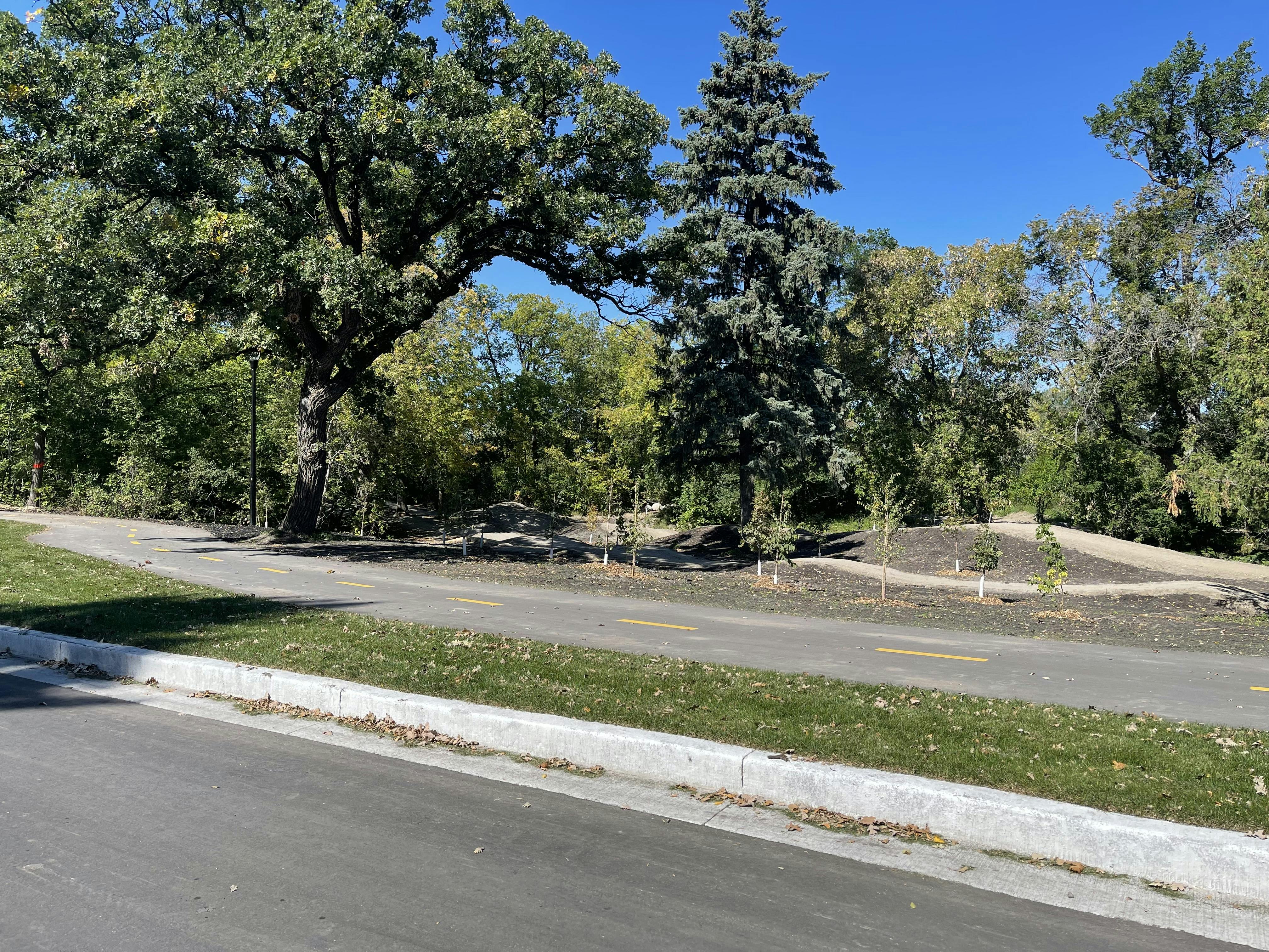
How can we help?
Visit winnipeg.ca/publicengagement to learn about some of the ways we can accommodate those who may need alternative access to engagement or information.
For inquiries or those who require alternate formats, interpretation or any additional accommodations to participate please contact winnipeg.ca/311 or 311.
Timeline
-
Project launch
Wellington Crescent Riverbank, Path, and Roadway Project has finished this stageAugust 2018
-
Site investigation & functional design
Wellington Crescent Riverbank, Path, and Roadway Project has finished this stageCollect data and evaluate options
August 2018 - March 2019
-
Property owner meeting
Wellington Crescent Riverbank, Path, and Roadway Project has finished this stageApril 2019
-
Traffic study
Wellington Crescent Riverbank, Path, and Roadway Project has finished this stageFall 2019 - spring 2020
-
Property owner meeting
Wellington Crescent Riverbank, Path, and Roadway Project has finished this stageJune 2020
-
Preliminary design
Wellington Crescent Riverbank, Path, and Roadway Project has finished this stageSummer 2020
-
Public engagement
Wellington Crescent Riverbank, Path, and Roadway Project has finished this stageJune to July 2020
-
Detailed design
Wellington Crescent Riverbank, Path, and Roadway Project has finished this stageFall 2020
-
Construction begins
Wellington Crescent Riverbank, Path, and Roadway Project is currently at this stageWinter 2020/21

Important Links
Who's Listening


Type of Engagement

Listen & Learn
Share feedback on pre-determined options.